San Antonio River Walk Maps
Parking maps, accessibility guides, and helpful resources for exploring the River Walk
Find your way around the San Antonio River Walk with helpful maps for Downtown, Museum Reach, parking, and accessible routes. Whether you're planning your first visit, looking for a convenient place to park, or exploring a new stretch of the river, these resources make it easier to navigate San Antonio's most iconic destination.
Browse the River Walk maps below to find the one that fits your plans, then explore the surrounding attractions, restaurants, and scenic pathways that make each area unique.
Which River Walk Map Should I Use?
- Exploring Downtown? Start with the Downtown River Walk map for an overview of the area's pathways and nearby destinations.
- Looking for parking? Use the Downtown Parking Map to find parking areas near the River Walk.
- Planning an accessible route? Review the River Bend or Museum Reach accessibility maps to identify useful access information before your visit.
- Exploring beyond Downtown? Check the Extended River Walk Map for additional pathways and areas to discover.
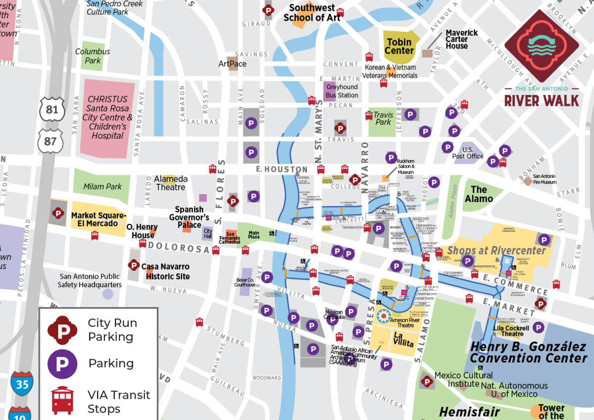
Downtown San Antonio River Walk Parking Map
Find parking areas near Downtown River Walk attractions, restaurants, and hotels.
Downtown River Bend Accessibility Map
Review accessible entrances and routes around the Downtown River Bend.
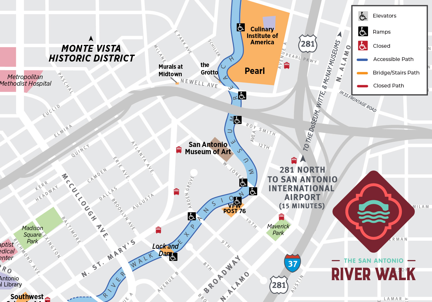
Museum Reach Accessibility Map
Plan your visit to Museum Reach with a map highlighting accessibility information.
Extended San Antonio River Walk Map
Explore additional sections of the River Walk using a map provided by the San Antonio River Authority.
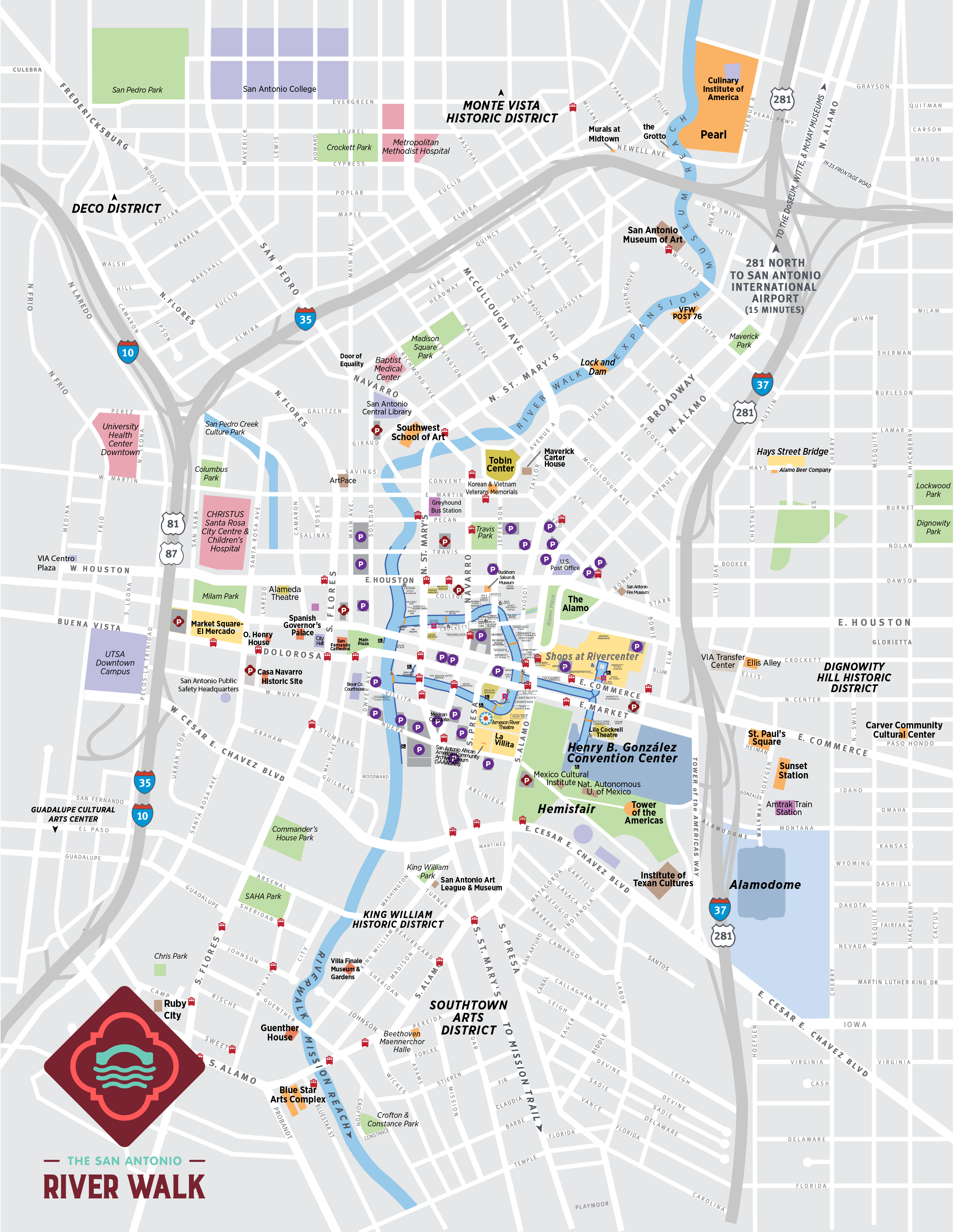
Downtown San Antonio River Walk Map
Get an overview of Downtown River Walk pathways and nearby destinations.
More To Explore on the San Antonio River Walk
72 Hours in San Antonio for the Annual Ford Holiday River Parade
Planning a trip for the Ford Holiday River Parade? Make the most of Thanksgiving weekend with a festive 72-hour San Antonio itinerary featuring…
8 Amazing Family Adventures Along the San Antonio River Walk
Looking for family-friendly things to do on the San Antonio River Walk? From colorful playgrounds and outdoor adventures to interactive museums and…
April Events on the River Walk
Looking for San Antonio River Walk events in April? Spring brings a lively mix of cultural celebrations, outdoor activities, art exhibitions…
10 Free Things to Do Along the San Antonio River Walk in November
Looking for free things to do in San Antonio in November? The San Antonio River Walk and its surrounding neighborhoods offer plenty of ways to enjoy…
Where to Eat on Christmas Day Along the San Antonio River Walk
Looking for restaurants open on Christmas Day in San Antonio? The San Antonio River Walk and nearby downtown restaurants offer festive ways to…
FAQs
Can I download a San Antonio River Walk map?
The page provides links to view River Walk maps. Whether each map can be downloaded depends on the format of the linked resource.
Is there a map of Museum Reach?
Yes. The North Path/Museum Reach Accessibility Map provides information for planning a visit to that section of the River Walk.
Are there accessibility maps for the River Walk?
Yes. The page provides accessibility maps for the Downtown River Bend and North Path/Museum Reach areas.
Is there a parking map for the San Antonio River Walk?
Yes. The Downtown Parking Map helps visitors locate parking areas near the River Walk.
Where can I find a map of the San Antonio River Walk?
Visitors can explore maps for Downtown River Walk, parking, accessibility, and extended River Walk routes on this page.
Explore More of the San Antonio River Walk
Your River Walk adventure starts with a great plan. Once you've found the map you need, discover the lively restaurants and attractions of Downtown, explore the arts and culture of Museum Reach, or enjoy the scenic trails and historic connections of Mission Reach.
Browse things to do, find your next favorite dining spot, and explore upcoming events as you plan your visit to San Antonio.